Saturday, April 24, 2010

Boozeman, Lincoln and Pryor all promised in 2009 to cooperate to get federal money appropriated to buy sale-barn property; instead, their failure to act has resulted in wet-prairie land north and west of the National Cemetery being dredged and filled for burial sites

Fayetteville National Cemetery photo set. Scroll to bottom of set for more of today's photos
This didn't have to happen. Could it be related to the fact that none of the three is a U.S. military veteran? Or did they have more important people's votes in mind? The percentage of veterans who vote is pretty high. The right to vote has always been a reason for many to agree to fight to protect our Democratic form of government. DSCN8289 
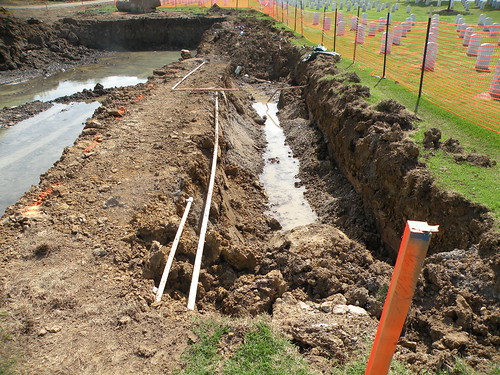
Please click on image to ENLARGE view of land dredging at Fayetteville National Cemetery on April 23, 2010.

Monday, April 19, 2010

Watershed workshop announcement from Matthew Epps of the Watershed Erosion Prediction Project


The Watershed Conservation Resource Center (WCRC) will be hosting Wildland Hydrology’s “Applied Fluvial Geomorphology” (Level 1) short course November 8-12, 2010.  This course will be held in Fayetteville, AR.  The Level 1 course is a prerequisite to attending the Level 2 course.  Registration for the course is now open.  Space is limited and the courses will fill quickly.  A completed registration form and a deposit payment are required to secure your place in the course.  Registration forms and additional information can be found at the WCRC website:http://www.watershedconservation.org/AFG_2010.html

Course Description:
The Applied Fluvial Geomorphology Course is an introductory course designed to familiarize students with the fundamentals of river behavior, the general principles of fluvial geomorphology, sedimentation, hydraulics, restoration, fish habitat improvement, riparian grazing management, and stream bank erosion. Applications of these principles are presented utilizing a stream classification system. Problem solving techniques for watershed management, riparian assessment, fish habitat structure evaluation, stream restoration, non-point source pollution and the integration of ecosystem concepts into watershed management are taught. A combination of both lecture and field application are provided.  This course is a prerequisite for the River Morphology and Applications, River Assessment and Monitoring and River Restoration and Natural Channel Design courses. This has been the basic river morphology course offered throughout North America since 1986.

If you have any questions about registration for this course please contact Lori at (479) 444-1916 or llinn@watershedconservation.org.

Thank you,

Matt

Matthew A. Van Eps, PE
Associate Director
Watershed Conservation Resource Center
380 W. Rock St.
Fayetteville, AR 72701
(501) 352-7294

Friday, April 16, 2010

Earth Day Festival began Friday night with Caring for Creation at Mount Sequoyah; Earth Day at World Peace Wetland Prairie from 1 to 5 p.m. Sunday, April 18, 2010, offers eduction and fun for all ages

Please click on image to ENLARGE for closer view of sample photos from WPWP.
PLEASE double-click the image to ENLARGE view and ENLARGE further with your computer's tools to read small type. For more about World Peace Wetland Prairie please see www.flickr.com/photos/7295307@N02/collections/ www.flickr.com/photos/7295307@N02/collections/   
PLEASE double-click the image to ENLARGE view and ENLARGE further with your computer's tools to read small type.

MANY REASONS TO PROTECT LAND SUCH AS WORLD PEACE WETLAND AND PINNACLE PRAIRIE FOREVER:
World Peace Wetland Prairie is the riparian zone of a small stream that historically was fed by seep springs and rainwater from three directions when the first westward immigrants settled Fayetteville, Arkansas. World Peace Wetland Prairie has the deepest layer of dark, rich soil in its subwatershed because leaves and other vegetative matter accumulated as the flowing water slowed and soaked into the absorbent soil and enriched that soil. Pinnacle Foods Inc.'s mounded wet prairie to the west is the main source of clean water flowing to World Peace Wetland Prairie at this time. Before the railroad was built, water flowed off Rochier Hill to the northwest and from the prairie and savannah to the north of WPWP that has been replaced by fill dirt and paving for apartments. Water from the east and north slopes of the high land where Pinnacle Foods Inc. now sits flowed to WPWP along with all the water from the high ground near 15th Street, which moved north to WPWP before flowing east to the Town Branch of the West Fork of the White River. Such remnants of prairie help keep the water where it falls and recharge the groundwater. Like the many similar remnants of such prairie in our diverse geographical area, WPWP and Pinnacle Prairie are the surface manifestation of a significant bedrock fault. Such sunken wetland is a characteristic feature that appears above geological faults worldwide. The Karst map of Washington County Arkansas shows the WPWP watershed in red, meaning that it is a critical groundwater recharge area. Preserving such depressional wetland in our city is the least expensive way to reduce downstream flooding and siltation of our water supply. Hundreds of native plants grow. Many birds and other wildlife prosper on healthy wetland vegetation. And prairie vegetation sequesters carbon dioxide and cleans the ground water.

KEEP the WATER where it FALLS!